Main Menu
AORC Libraries
Browse Items in MEDMAPS (16 total)
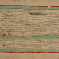
Peutingeriana tabula itineraria, segmentum II, segmentum IV
Description: Engraved map by Franz Christoff Scheyb.
32.5 x 56 cm.
32.5 x 56 cm.
Publisher: Budapest: Royal Printing Office, 1825.
Contributor: Edited by Matija P. Katancic.
Engraved by S. Lehnhardt.
Engraved by S. Lehnhardt.
Collection: MEDMAPS

[Nautical chart of the second part of the Mediterranean Sea, from Malta to Alexandretta and up to Constantinople, carefully drawn by Captain Nikolaos Kefalas, of Zakynthos Island.]
Description: Engraved map by Nikolaos Kefalas.
99 x 67.5 cm.
99 x 67.5 cm.
Publisher: Paris: Alexander Risomos, 1818.
Contributor: Engraved by Pierre Picquet.
Collection: MEDMAPS
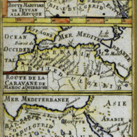
Route Maritime de Tetuan à la Mecque - Route de la Caravan de Maroc à Quibriche - Route de la Caravane de Quibriche à la Mecque
Description: Engraved maps by Alain Manesson Mallet.
3 maps in 1, 15 x 10 cm.
3 maps in 1, 15 x 10 cm.
Publisher: Published in Afrique Ancienne et Moderne
(Mallet’s Description de l’ Univers, volume 3)
(Mallet’s Description de l’ Univers, volume 3)
Contributor: From the collection of the Tangier American Legation Museum (Morocco), M.074
Collection: MEDMAPS
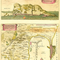
Plan de la ville de Gilbraltar [sic]... Aftekening van Gibraltar
Description: Engraved map by Pierre Husson.
17 x 36.5 cm.
17 x 36.5 cm.
Publisher: The Hague
Contributor: From the collection of the Tangier American Legation Museum (Morocco), M338.
Collection: MEDMAPS
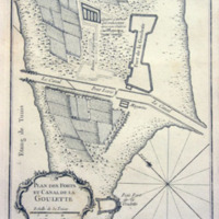
Plan des forts et canal de la Goulette
Description: Engraved map by Nicolas Bellin.
21.5 x 17.2 cm.
21.5 x 17.2 cm.
Publisher: Paris, 1764.
Contributor: From the collection at the Centre d'Études Maghrébines à Tunis, CRM 21
Collection: MEDMAPS
_193de1ef06.jpg)
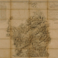
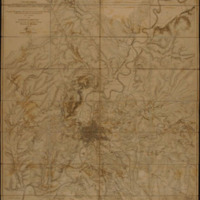
Carte der europaeischen Türkey nebst einem Theile von Kleinasien in XXI Blattern
Description: Engraved map by Franz von Weiss.
In 21 sheets (sheets 11 and 12 exhibited)
300 x 196 cm.
In 21 sheets (sheets 11 and 12 exhibited)
300 x 196 cm.
Publisher: Vienna: Quarter Master General of the Austrian Army, 1829.
Contributor: From the collection of the Gennadius Library, American School of Classical Studies (Athens), GT…
Collection: MEDMAPS
Carta del isol e regno de Sardegna
Description: dedicata alla Maesta del Re Carlo Alberto Primo...
Publisher: Rome : Ulderico Bossi, 1898.
Contributor: From the collection at the American Academy in Rome, Top 052.2 Sar B
Collection: MEDMAPS
Carta topografica di Roma e dei suoi contorni fino alla distanza di 10 miglia fuori le mura.
Description: Engraved map by Helmuth von Moltke.
Publisher: Berlin: Shropp, 1852.
Contributor: Engraved by Enrico Brose.
Collection: MEDMAPS
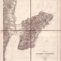
Portion of Eastern Palestine
Description: Map by Claude R. Conder.
Publisher: London: Stanford’s Geographical Establishment, ca. 1881.
Contributor: From the collection of the W. F. Albright Institute of Archaeological Research (Jerusalem), map…
Collection: MEDMAPS
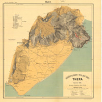
Sudöstlicher Theil der Insel Thera
Description: Lithographed map drawn by Paul Wilski.
Publisher: Berlin: Dietrich Reimer, 1899.
Contributor: From the collection of the Cyprus American Archaeological Research Institute (Nicosia, Cyprus) 939.1…
Collection: MEDMAPS

