Main Menu
AORC Libraries
Browse Archive Items (14642 total)

[Nautical chart of the second part of the Mediterranean Sea, from Malta to Alexandretta and up to Constantinople, carefully drawn by Captain Nikolaos Kefalas, of Zakynthos Island.]
Description: Engraved map by Nikolaos Kefalas.
99 x 67.5 cm.
99 x 67.5 cm.
Publisher: Paris: Alexander Risomos, 1818.
Contributor: Engraved by Pierre Picquet.
Collection: MEDMAPS
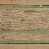
Peutingeriana tabula itineraria, segmentum II, segmentum IV
Description: Engraved map by Franz Christoff Scheyb.
32.5 x 56 cm.
32.5 x 56 cm.
Publisher: Budapest: Royal Printing Office, 1825.
Contributor: Edited by Matija P. Katancic.
Engraved by S. Lehnhardt.
Engraved by S. Lehnhardt.
Collection: MEDMAPS

